Common Operating Picture

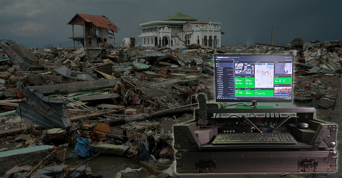
No matter what the public safety networks look like in 20 years, they are sure to have core capabilities grounded in location-based services.  A critical component of any successful rescue operation is time.  Decision cycle time can be optimized by having the precise location of buildings, core services, emergency service resources, and disaster relief sites. This information is critical to disaster relief teams and public...

Read More

The relationship between weather and emergency management (not to mention emergency preparedness) is fundamental and can be quite complicated. Weather causes many of the disasters that require an emergency response, yet awareness of conditions is essential for management of incidents unrelated to weather as the cause. For sure, meteorological awareness can have a profound effect managing the extent of destruction to life and property to...

Read More

Ask any soldier or first responder and they will tell you of the importance of shared tactical video for decision-making during edge operations. Drones can now be cued to launch in real-time for overwatch. Military working dogs routinely carry low light infrared imagers that enable off-leash shared awareness for what the dog sees even though he is 200 meters forward. Video is core to intelligence...

Read More

Much like military conflict, manmade and natural disasters present similar challenges of uncertainty, complexity and variability. These time-constrained and chaotic decision environments require rapid adaptation and an ability to pivot quickly to changes in the environment. The complexity of the event, coupled with time compressed decision space and the severity of the potential consequences, creates conditions that are unforgiving of error. Given the austere and...

Read More

Ask anyone who has responded to a natural or manmade disaster and they will tell you, these events create the mother of all non-predictive inter-agency mashups. The multitude of agencies responding from outside of the incident area creates a need for hyperlocal services that assist in navigation, but also enable the finding and discovery of resources in the affected area of operation that can be...

Read More

It's that time of year. Every fire season, millions of acres across the world burn during wildland fire events. Worse, between 2000 - 2019 alone, more than 400 wildland firefighters lost their lives fighting these fires while protecting civilians, homes, and forests. While the hazards faced on the fire line can include burnovers/entrapments, heat-related illnesses and injuries, smoke inhalation, vehicle-related injuries (including aircraft), slips, trips,...

Read More

Blueforce has been working diligently over the last six months on our new BlueforceTACTICAL and BlueforceEDGE ports to Linux. Much of our work has been in developing next generation Blueforce Plugins for the Linux platform that support and extend capability to shrink the footprint, but also the Space, Weight, and Power (SWaP) requirements such that the code can run on “System on Chip” containers, but...

Read More

Exciting times indeed.  Our partnership with Wilcox Industries, Samsung, Providence UK, Tactical Equipements FR and VARSPEX (CA) plus active international engagement pushes Blueforce rapidly into global markets as we add new service providers, value added resellers, and technology partners. With these partnerships comes expansion into new geographies, here in the United States, but also globally. With these new geos comes the need to support a...

Read More

Distributed sense-making from K9 and military working dog sensor arrays deployed on Blueforce designed harness systems.  Learn more about Integrated K9 Operations for Special Tactics Teams using Blueforce, as broadcast on the Discovery Channel. ...

Read More

Situational awareness is a critical component for Incident Commanders making life and death decisions in time constrained environments. As the internet has matured, and public safety IoT/sensors are deployed, the commander now has access to a wide array of data that transcends mere location and map markups. With this proliferation of public safety sensors, drones, robotics, and now smart city infrastructure, the commander has an ever...

Read More