Blueforce Plugin Series: Tagger, Tracker, and Locators (TTL)
No matter what the public safety networks look like in 20 years, they are sure to have core capabilities grounded in location-based services. A critical component of any successful rescue operation is time. Decision cycle time can be optimized by having the precise location of buildings, core services, emergency service resources, and disaster relief sites. This information is critical to disaster relief teams and public safety personnel in order to protect life and reduce property loss. The Global Positioning System (GPS) is a mission critical technology in addressing these needs.
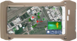
Accountability is a core foundation of situational awareness. Up to the second awareness of responder team crew size, readiness, location, and status at all times are critical to maintaining command situational awareness. Location services via GPS provides commanders with enhanced operational efficiency for their emergency response teams. The ability to effectively identify and view the location of police, fire, rescue, and individual vehicles or drones, and how their location relates to an entire network of incident resources in a geographic area, has resulted in enhanced operational efficiency.
Since our inception, location has been one of the three legs of the Blueforce stool with processed sensor data and incident collaboration capabilities combined to deliver on the promise of shared situational awareness. Yet, various modalities of the operational environment drive different approaches to shared location. To that end, the entire Blueforce product line includes our “location services bus”, a means to derive location via our published and documented API and SDK, as well as a number of out of the box plugins and interfaces. What follows are the off-the-shelf devices supported today (call us for Government off the Shelf and/or purpose built taggers and trackers), plus a number of API interfaces.
GPS on Enduser Device (EUD)
All Blueforce products crossing Tizen 4, Android, iOS, Linux, and Windows provide a native interface to use GPS services native to the enduser device (EUD). Where available on an EUD, Blueforce pulls latitude, longitude, altitude, and magnetometer to collect and share location and direction of travel. As well, native to the Blueforce platform is dynamic conversion to the Military Grid Reference System (MGRS) which can be transported alongside of LAT/LON, and/or replaced entirely by movement of MGRS data specific to a human, sensor, or autonomous aviation/ground vehicle.
Products: BlueforceTACTICAL, BlueforcePATROL, BlueforceBEACON, and BlueforceCOMMAND
OBD2 Trackers
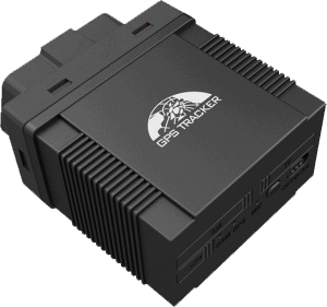
OBD II connectors in vehicles and equipment allow for easy diagnostic and analysis of the vehicle through various devices including OBD GPS trackers. For OBD2 GPS tracking, these devices enable plug-and-play with the vehicle, allowing not only for power to supply the OBD GPS tracker, but also for you to get extra features like fuel monitoring or driving speed.
Products: BlueforceEDGE
DeLorme InReach
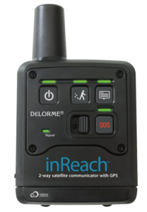
The DeLorme inReachâ„¢ satellite communicators are affordable, two-way, satellite communications devices. It’s about the size and weight of a smartphone, but much, much more durable. Choose inReach to send and receive messages to mobile numbers, email addresses and social networks from the palm of your hand. Choose the original inReach to keep it simple – it floats too.
Products: BlueforceEDGE
GlobalStar SPOT Gen4
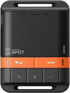
The GlobalStar SPOT Gen4 Satellite messenger lets family, friends, and colleagues know you are OK and also provides an SOS function if the unexpected should happen by utilizing the GlobalStar satellite network. SPOT Gen4 provides a critical life-saving line of communication when teams travel beyond the boundaries of reliable cellular service.
Products: BlueforceEDGE
Bad Elf GPS PRO
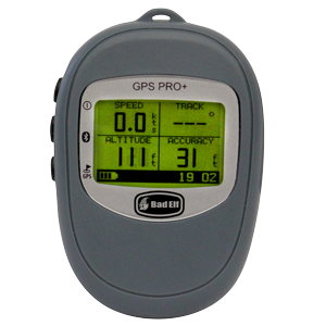
The original Bad Elf GPS Pro received rave reviews from the most demanding customers in military, commercial, and private aviation. The new Bad Elf GPS Pro+ adds GLONASS satellite capability, USB file system access to data logs, and a barometric sensor for altitude. This GPS receiver, with 24 hour battery life and the capacity to log a full week on the road, just got better.
Products: BlueforceTACTICAL (Android only)
TRX NEON Tracker
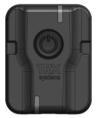
The TRX NEON® Personnel Tracker improves safety and situational awareness for industrial, security, public safety, and defense users. Personnel Tracker provides ubiquitous 3D location, tracking, and mapping for personnel operating indoors, underground, and in any GPS-denied environment.
Products: BlueforceTACTICAL (Android only)
WarLoc (TM) Tracker
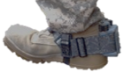
WarLocâ„¢ is a GPS-denied localization device for dismounts. It is used to increase the safety and security of both the warfighters and first responders. The device attaches to the foot of operators and sends location information to a smartphone. WarLoc measures user position in all GPS-denied locations, from underground to skyscrapers. WarLoc technology is robust to GPS jamming and communications dropouts.
Products: BlueforceTACTICAL (Android only, Export Controlled)
Blues Wireless Notecard
![]()
The Notecard combines prepaid global cellular, low-power hardware, simple software design, and secure communications into a single SoM that can be quickly integrated into GOTS or COTS ground sensors. JSON in – JSON Out: Send data over wireless with just two lines of code, and route data to your own BlueforceEDGE instance via our Location REST/JSON API (see below).
Products: BlueforceEDGE
BlueforceEDGE Location REST/JSON API
![]()
Products: BlueforceEDGE
Enduser Device Location Services API
![]()
Products: BlueforceTACTICAL (Android and Linux only)
For more information or to request a demo, visit us at https://www.blueforcedev.com, or send an email to info@blueforcedev.com.
